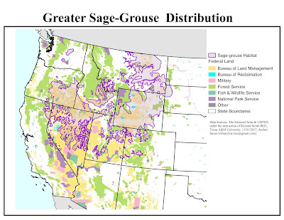
The greater sage-grouse is the largest in North America. The species has been recognized as threatened by several national and international organizations due to habitat loss. So I made a map using Quantum GIS detailing the areal extent of the sage-grouse habitat within the Federally owned land.
(click to view enlarged map)
Some of the processes involved in creating this map included adding geospatial data and setting map projections, styling data layers by categorical attributes, and crafting a map composition using QGIS Print Composer. The types of Federal land was styled in the legend with standard Bureau of Land Management colors in order to preserve consistency with other BLM maps.
As you can see, the bird resides mainly in BLM-owned land, followed by publically owned land, and land owned by the Forest Service and National Park Service.


No comments:
Post a Comment